
Damaging Winds and Tornado Threat Wednesday
The entire state of Mississippi is under a moderate risk (4/5) tomorrow for the potential for damaging winds. Overall this is the most expansive moderate risk zone I think I’ve ever seen. The risk extends into southern Louisiana and all of western Alabama as well. Plus Memphis has been included.
The main concern is the potential for strong winds within a sharp line of storms that will progress east from Louisiana into Mississippi and Alabama as the afternoon goes on tomorrow. Ahead of this will be strong winds (gusts 50+ very possible) without any storms happening at all. This could cause some localized power outages, so have a way to get your warnings tomorrow even if the power is out.
Additionally, there is a tornado concern both within the line and along the southern extent of the line where the line could break into clusters of supercells. I agree with the SPC that right now, the greatest risk of that happening will be along and east of I59. Any tornadoes that form in individual cells have the potential to be intense. Even within the line, it is easy to imagine getting EF2+ plus damage from spin ups as this line will be progressing quickly and the background winds will already by pushing 70 mph. Kind of like how tornadoes in the eyewall of a hurricane enhance the already high winds.
So first I’m going to dive into the convective allowing models and talk about why the damaging wind risk is just so widespread.

SPC Day 2 Wind Probabilities, with the hatching showing potential for 70+ mph winds. This is just an incredible extent to that risk.
Looking at the high resolution models, I’m going to highlight a few things. First of all, the very strong 850 mb (low-level) jet present and the potential for downdrafts to bring that wind to the surface. The next thing will be mid-level dry air surges (700 mb level, but this is a thing from 850-500 mb) that cause the downdraft speed potential to be higher as the evaporation causes the air to lose buoyancy and sinks faster. Finally, going to marvel at the surface pressure gradient as this presents an unusual gradient wind threat ahead of the line and only serves to enhance the wind threat within the line.

12z HRRR from 3/29/22 showing the 850 mb winds. Image from pivotalweather, with my own annotations.
That low level jet is strong. It presents part of the logic of the expansive high wind risk as downdrafts will bring some of that wind down to the surface. This also presents some of the bowing danger and provides abundant low level shear for tornadoes to spin up.

12z GFS on 3/28/22 showing relative humidity at 700 mb. Image is from pivotalweather and I drew up the annotations.
This surge of dry air is almost certainly going to become “entrained” within the line as rear inflow jets (RIJs) get going within the convection present in the line. This will lead to strong winds getting pulled down to the surface and bowing segments where the potential for those 70+ mph winds will lie. Do note that some of it is hanging back in the southern extent, which is why the high wind risk is highest north of I12. A quick look at the 500 mb RH%s show additional pockets of this dry air surging toward the line, showing support through all of the mid-levels for this extra bowing.
It is also worth noting that where you get these bows, you’re more likely to get embedded tornadoes nearby and those have a higher potential of being in that EF2 range than typical embedded tornadoes and also a potential to be longer lasting than the typical quick spin ups. Going to be a very long day for the radar operators up and down I55 and I65.

12z HRRR on 3/29/22, showing surface level pressures and wind speed in kts. Image from pivotalweather with annotations by Jacob Caddell.
Tight pressure gradient with pressure falls from upper level support lead to strong winds ahead of any storms. This is something everyone in the region is going to notice, with gusts likely over 40 mph across Louisiana, Mississippi, and western Alabama. Additionally, pressure falls at the surface might support some discrete cells ahead of the line. This is a low probability thing imo, with lacking instability and lapse rates. I just want to note it could happen. Don’t fret over it, but take any cell that may form in front with a tornado warning very seriously!
Tornado Risk:
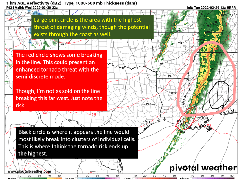
There are a couple of areas I have extra concern about, both along the southern extent of the line. Many of the high resolution models are showing some breaking of the line, which would lead to those cells having an increased chance of producing an intense tornado. The first area is across southern Louisiana, though I still have doubts it won’t still be a coherent line at that point. A line still presents the potential of embedded tornadoes, but a scenario where it breaks raises the tornado ceiling.
The second area is over into SE Mississippi and SW Alabama, where I (and the fine mets at the SPC) think a line break is more likely. The black circled region below is where I’d expect the greatest chances of strong tornadoes will be. So pay extra attention in that region.

The 12z HRRR from 3/29/22, showing a simulated radar depiction. Image from pivotalweather, with annotations by Jacob Caddell.
tl;dr version:
An extensive risk for damaging winds exists across all of the Lower Mississippi Valley and eastward into western Alabama. The greatest risk will be in segments of the line that bow out. In addition, strong winds ahead of the line will be very noticeable tomorrow with potential to knock out power in some locations. Have a way to get warnings without power due to this potential. Those winds will have gusts into the 40 mph range but gusts above 50 and even up to 60 are not unreasonable ahead of any storms.
There is also a tornado threat for stronger than normal and longer last than normal tornadoes within the line of storms. Take those spin ups as seriously as you would a tornado ahead of the line. In addition, there is some concern of the line breaking along the southern extent of the storms, which also increases the threat of strong tornadoes if it were to materialize. While I have some concern in southern Louisiana for that scenario, I still think the most likely spot would be farther east along and to the east of I59. The powerful shear available means it doesn’t take much of an updraft to get spinning and developing.
That’s the big picture going into tomorrow. I might have a short post looking at soundings tonight, and intend to have a nowcasting post tomorrow showing how the initial conditions are matching the models and what hints that may give to the evolution. Stay safe y’all.
Related Posts

Hurricane Season 2023 Preview: El Nino Returns

Gulf Low Will Bring Rain and Coastal Flooding

One For The Mardi Gras Skiers

Bust Out The Shorts For Mardi Gras

Hope You’ve Enjoyed Fall So Far. Looking Ahead At The Big Picture Into November.

The Media Coverage Of Ian Has Been Frustrating

Hurricane Ian To Make Second Landfall In Carolinas

Hurricane Ian Strengthens and Grows Larger With Landfall Tomorrow

NHC Forecasting Near Nightmare Scenario For Tampa
